GENERAL INFORMATION
Effective as of October 2022:
Water billing for the Hamlet of Gray will now be done annually. October is the new annual billing period cycle
Water billing for the Hamlet of Gray will now be done annually. October is the new annual billing period cycle
If you have just moved in the hamlet and need to arrange for your water hookup, please contact George Dierker to come take a meter reading and set you up. George may be reached at 306-738-2016
FOR FARMS & ACREAGES IN THE AREA:
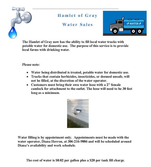
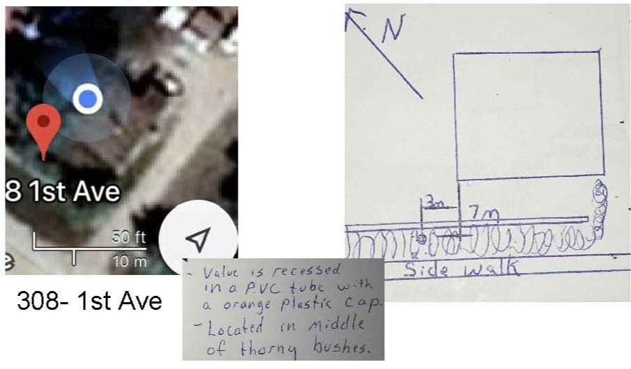
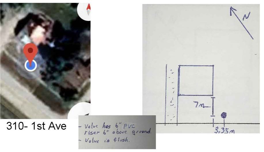
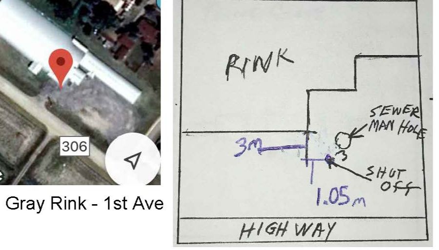
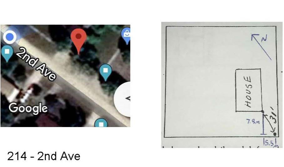
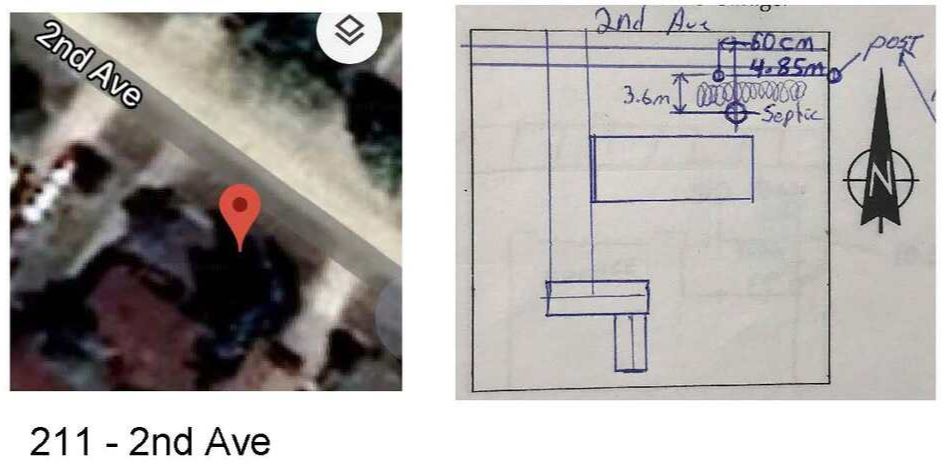
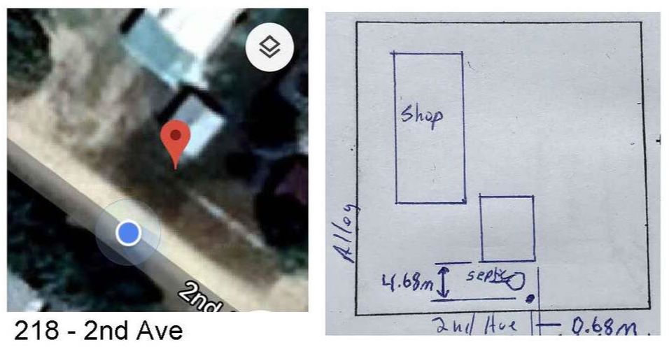
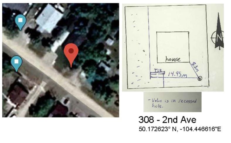
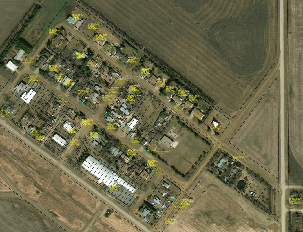
HAMLET OF GRAY SHUT OFF LOCATIONS
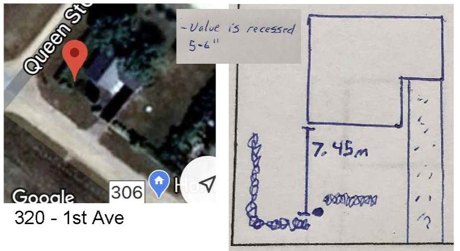
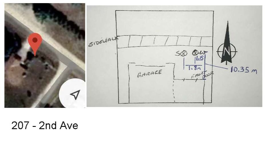
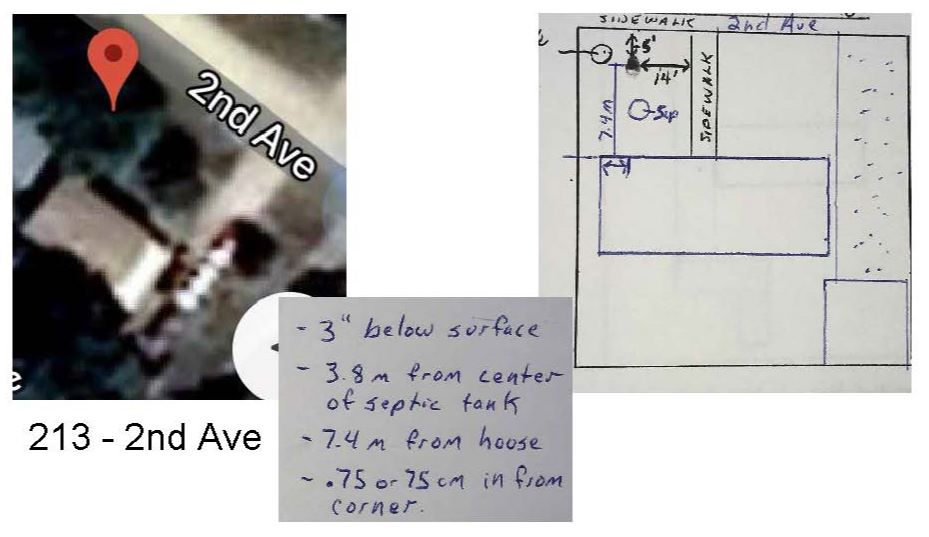
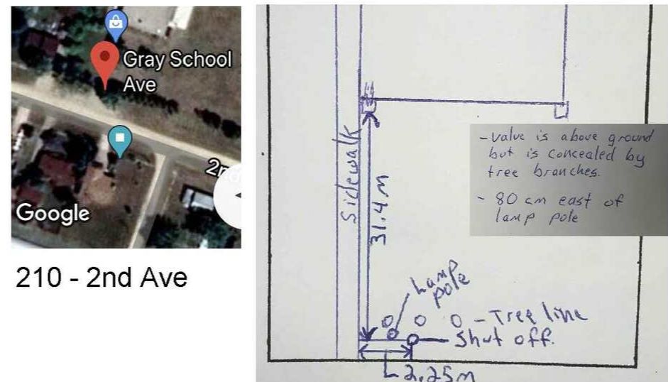
Over the years, many water turnoffs have been buried with landscaping projects. Because they were not installed in consistent locations, it has caused some headaches when water breaks have occurred.
The shutoffs were located and surveyed in manually in 2020, GPS locations were determined from satellite photography and are approximate
Click on images to enlarge to full size. Best viewed on a computer monitor.
1st Ave (Highway 306)
calibrated to satellite photo: UTM NAD83 Zone 13N
5557936.28 m N, 539365.93 m E,
LAT N 50.172325
LONG W104.448737
|
calibrated to satellite photo: UTM NAD83 Zone 13N
5557890.32 m N, 539426.47 m E,
LAT N 50.171907
LONG W104.447894
calibrated to satellite photo: UTM NAD83 Zone 13N
5557784.21 m N, 539585.76 m E,
LAT N 50.170942,
LONG W104.445674
|
calibrated to satellite photo: UTM NAD83 Zone 13N
5557936.86 m N, 539365.93 m E,
LAT N 50.172325
LONG W104.448737
|
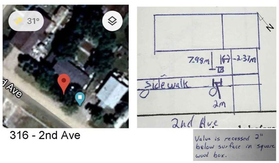
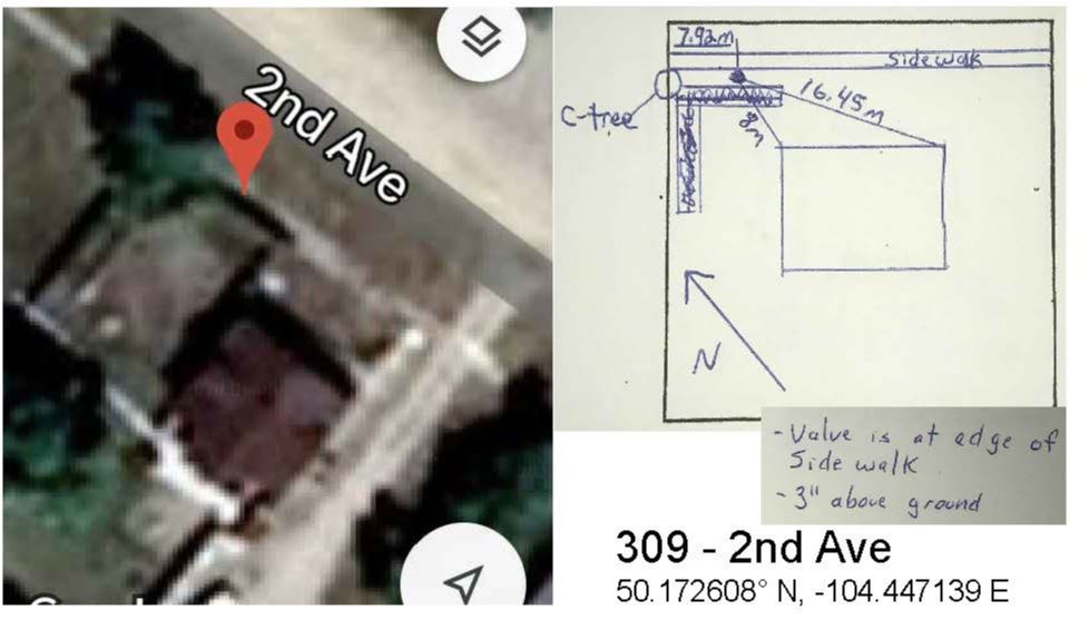
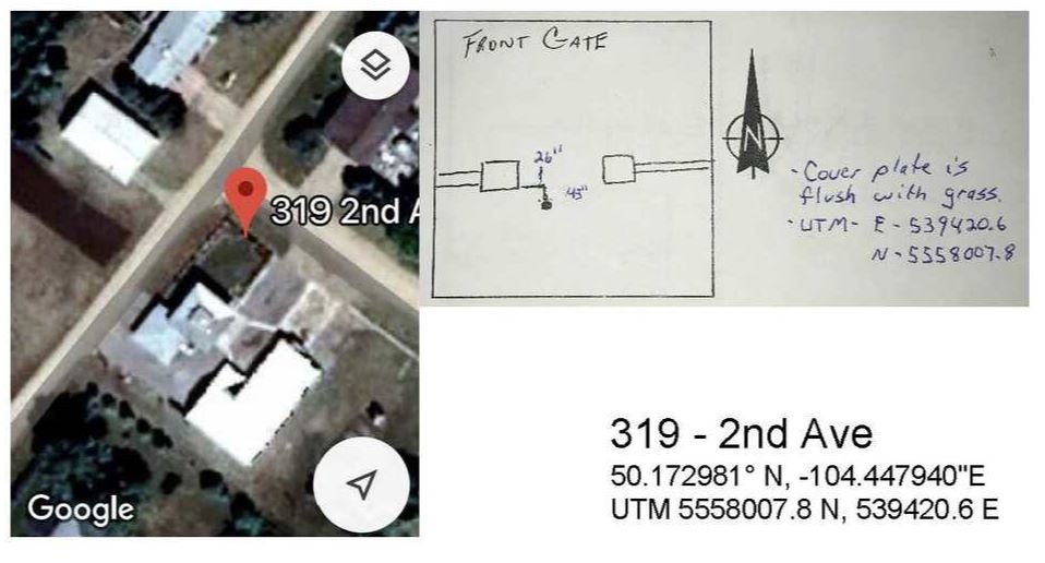
2nd Ave
calibrated to satellite photo: UTM NAD83 Zone 13N
5557820.15 m N, 539674.46m E,
LAT N 50.171260,
LONG W104.444428
calibrated to satellite photo: UTM NAD83 Zone 13N
55577870.94 m N, 539604.59 m E,
LAT N 50.171721
LONG W104.445402

calibrated to satellite photo: UTM NAD83 Zone 13N
5557870.94 m N, 539604.59m E,
LAT N 50.171721
LONG W104.445402
|
calibrated to satellite photo: UTM NAD83 Zone 13N
5557851.83 m N, 539675.82 m E,
LAT N 50.171545
LONG W104.444406
calibrated to satellite photo: UTM NAD83 Zone 13N
5557861.84 m N, 539658.37 m E,
LAT N 50.171636
LONG W104.444649
|
calibrated to satellite photo: UTM NAD83 Zone 13N
5557835.49 m N, 539662.14m E,
LAT N 50.171399
LONG W104.444599
calibrated to satellite photo: UTM NAD83 Zone 13N
5557883.02 m N, 539630.89m E,
LAT N 50.171828,
LONG W104.445032
|
calibrated to satellite photo: UTM NAD83 Zone 13N
5557969.0341 m N, 539515.0084 m E
LAT N 50.172609
LONG W 104.446646
calibrated to satellite photo: UTM NAD83 Zone 13N
5558004.71 m N, 539471.20 m E,
LAT N 50.172933
LONG W1047.447255
|
calibrated to satellite photo: UTM NAD83 Zone 13N
5557966.86 m N, 539480.13 m E,
LAT N 50.172592
LONG W104.447134
Calibrated to satellite photo:
UTM NAD83 Zone 13N
5558009.06 m N,
5394221.66 m E
LAT N 50.172976.
LONG W 104.447949
|

calibrated to satellite photo: UTM NAD83 Zone 13N
5557992.6973 m N, 5557992.6973 m E
LAT N 50.172825
LONG W 104.447138
|
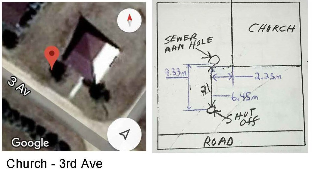
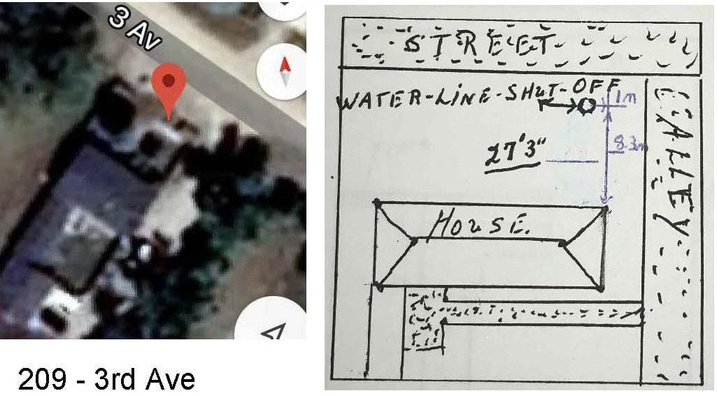
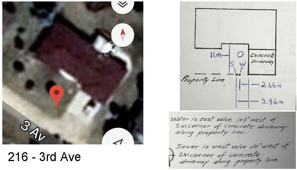
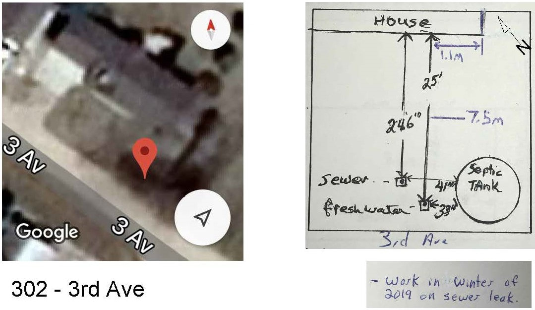
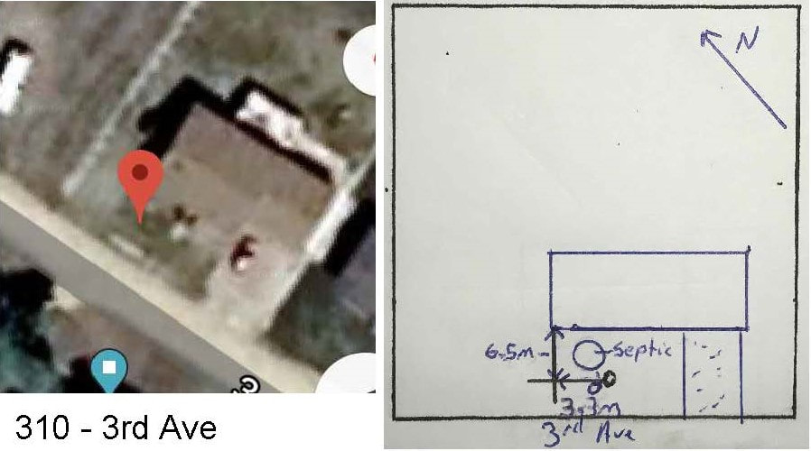
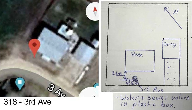
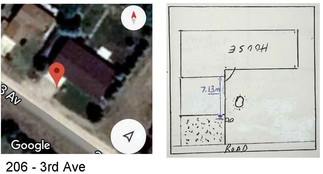
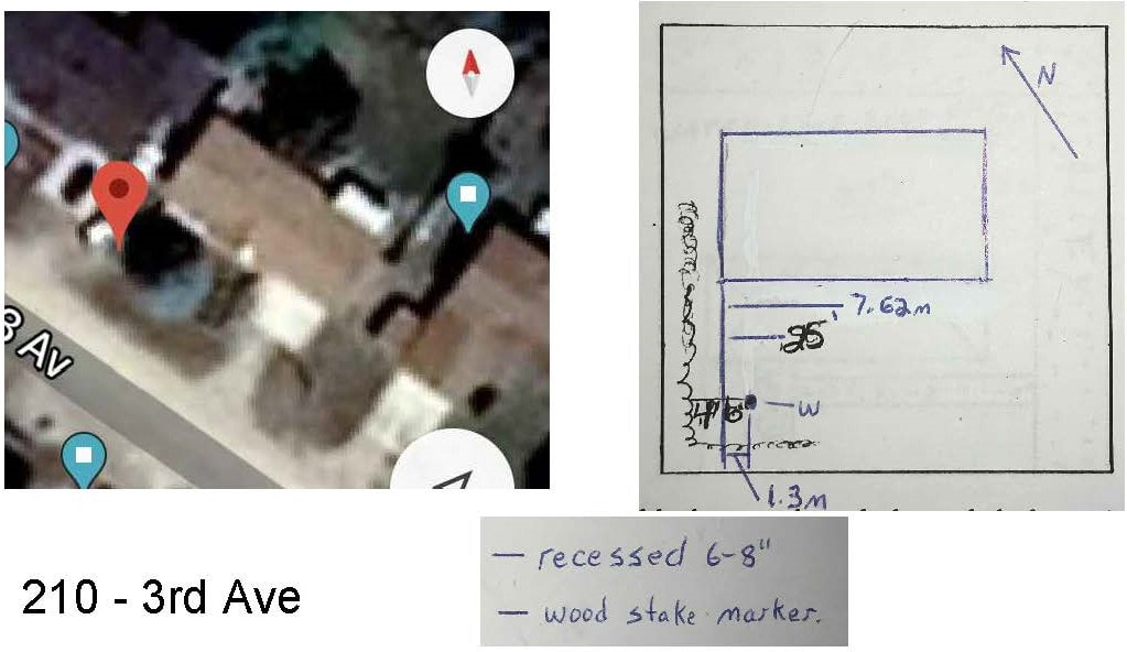
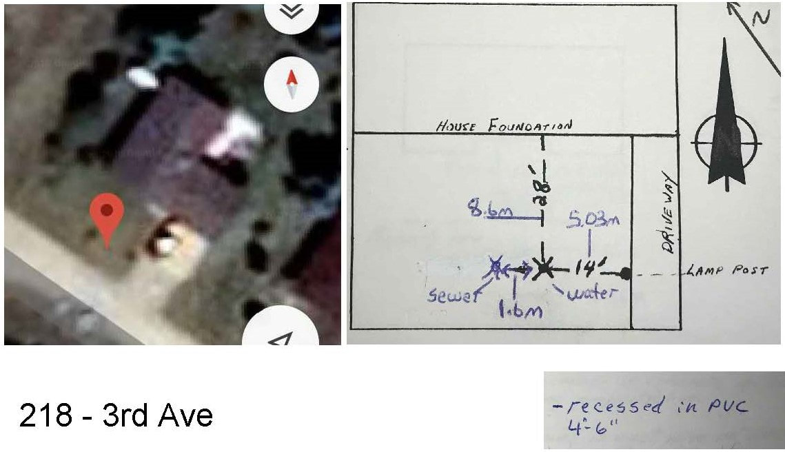
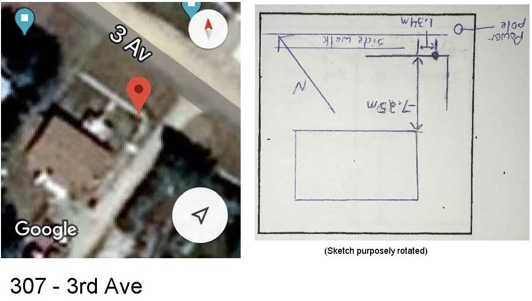
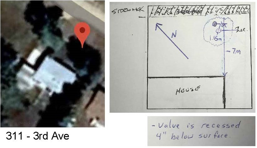
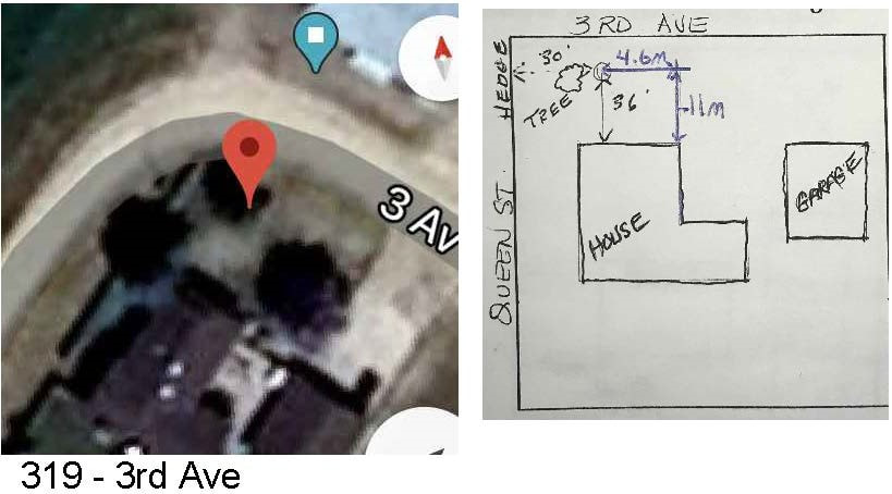
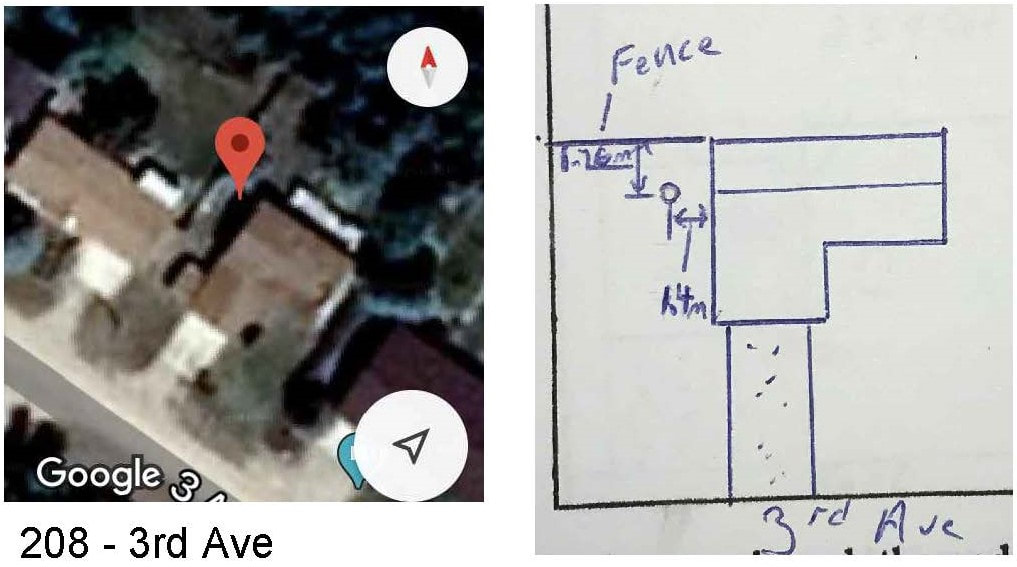
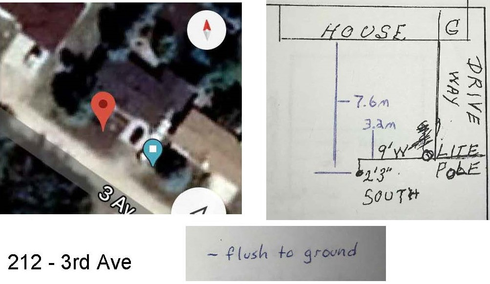
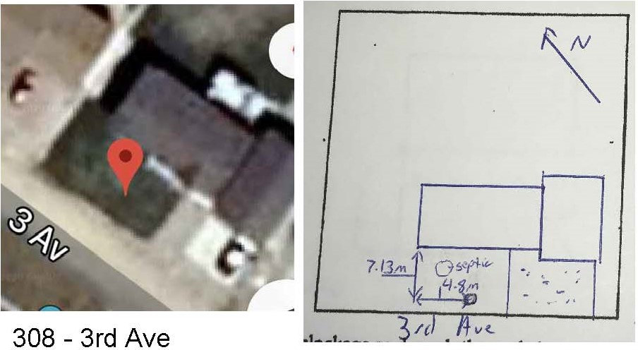
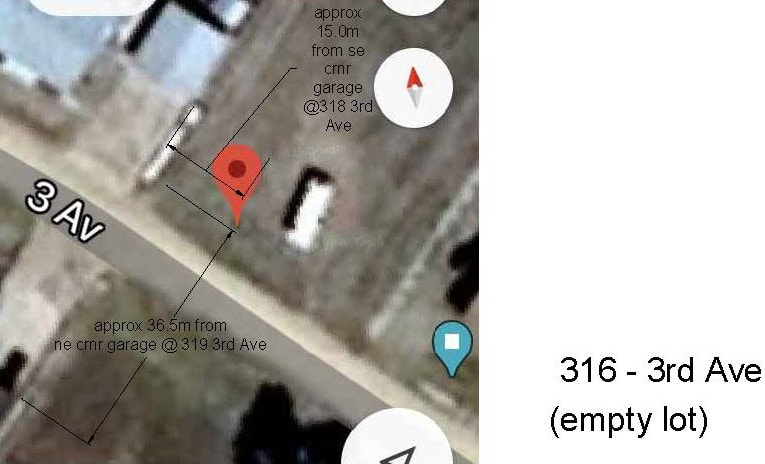
3rd Ave |
|
calibrated to satellite photo: UTM NAD83 Zone 13N
5557906.3560m N, 539788.0468m E, LAT N 50.172027, LONG W 104.442829
calibrated to satellite photo: UTM NAD83 Zone 13N
5557937.2197 N, 539710.0090 E, LAT N 50.172310, LONG W 104.443918
calibrated to satellite photo: UTM NAD83 Zone 13N
5557988.8041 N, 539676.2545 E, LAT N 50.172776, LONG W 104.444386
calibrated to satellite photo: UTM NAD83 Zone 13N
5558033.7145N, 539617.7638E, LAT N50.173184, LONG W104.445200
calibrated to satellite photo: UTM NAD83 Zone 13N
5558081.2082 N, 539553.1995 E, LAT N50.173616, LONG W104.446099
calibrated to satellite photo: UTM NAD83 Zone 13N
5558121.4909 N, 539502.9906 E, LAT N50.3173981, LONG W104.446798
|
calibrated to satellite photo: UTM NAD83 Zone 13N
5557927.15 N, 539756.79 E, LAT N 50.172216, LONG W104.443264
calibrated to satellite photo: UTM NAD83 Zone 13N
5557974.89 N, 539695.33 E, LAT N 50.172650, LONG W 104.444120
calibrated to satellite photo: UTM NAD83 Zone 13N 5558011.8749, 539643.3627 E, LAT N50.172986, LONG W104.444844
calibrated to satellite photo: UTM NAD83 Zone 13N
5558043.2266 N, 539569.6741 E, LAT N50.173273, LONG W104.445872
calibrated to satellite photo: UTM NAD83 Zone 13N
5558058.8618 N, 53548.2929 E, LAT N50.173415. LOG W104.446170
calibrated to satellite photo: UTM NAD83 Zone 13N
5558104.9843 N, 539493.7201 E, LAT N50.173833, LONG W104.446930
|
calibrated to satellite photo: UTM NAD83 Zone 13N 5557964.3033 N, 539743.4458 E, LAT N 50.172552, LONG W 104.443447
calibrated to satellite photo: UTM NAD83 Zone 13N
5557974.8911m N, 539695.3300m E, LAT N 50.172650, LONG W 104.444120
calibrated to satellite photo: UTM NAD83 Zone 13N
5558063.4539 N, 539576.0349 E, LAT N50.173454, LONG W104.445781
calibrated to satellite photo: UTM NAD83 Zone 13N
(VERY APPROXIMATE) 448103.4969 N, 539536.6802 E, LAT N50.173817, LONG 104.446328
|
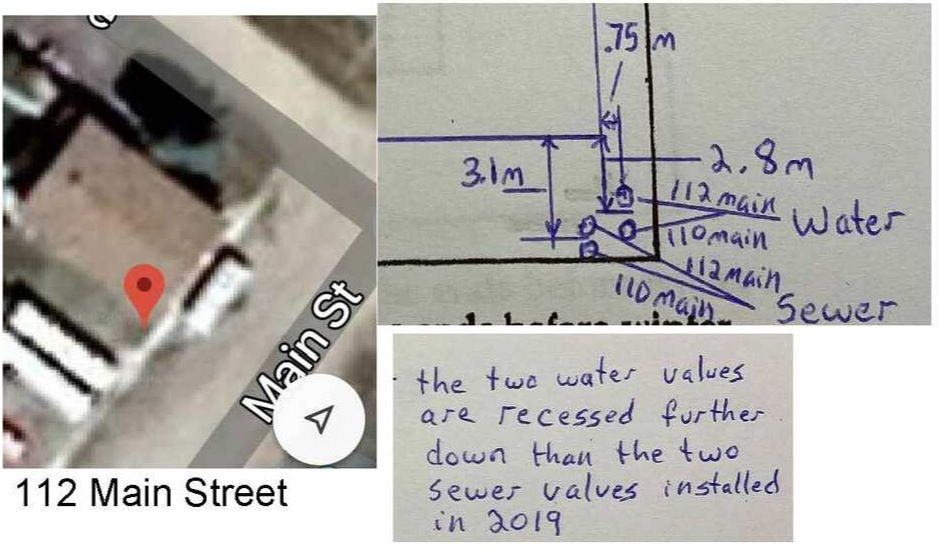
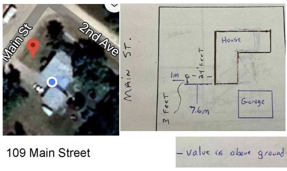
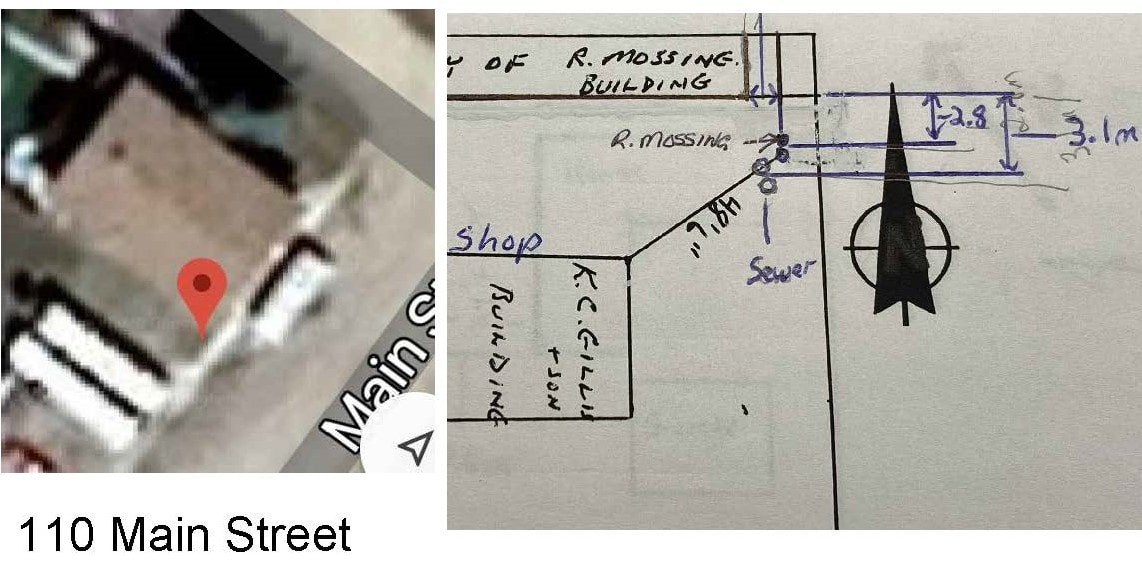
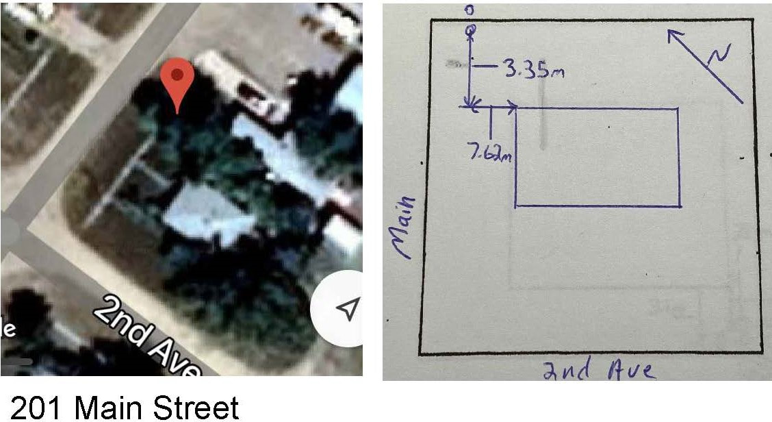
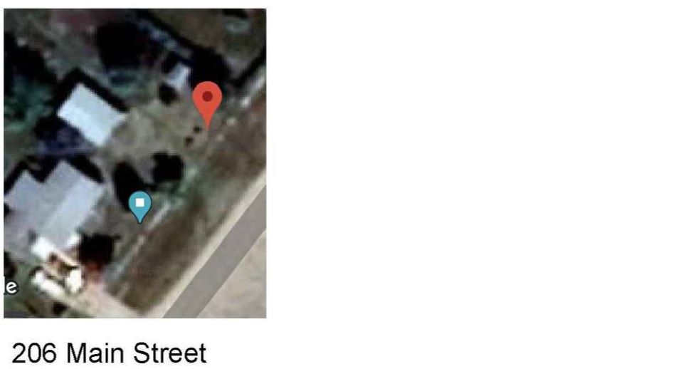
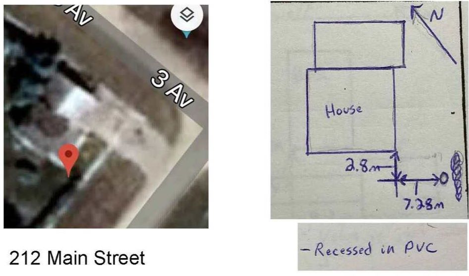
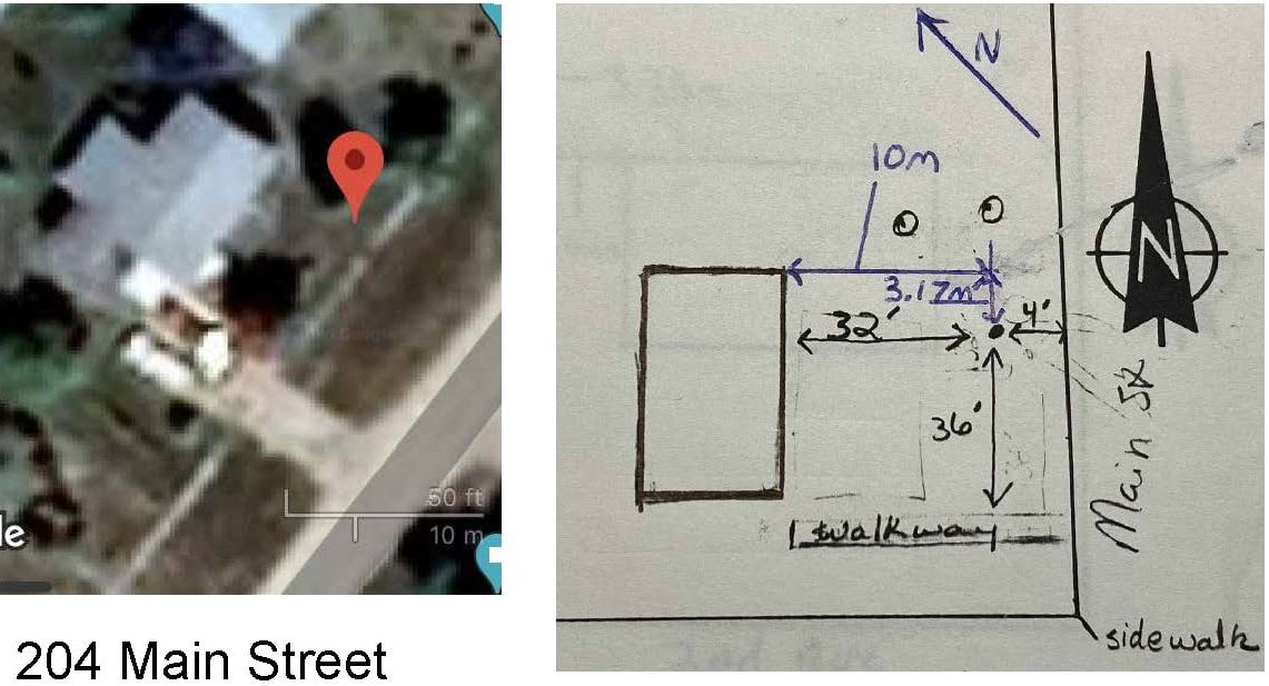
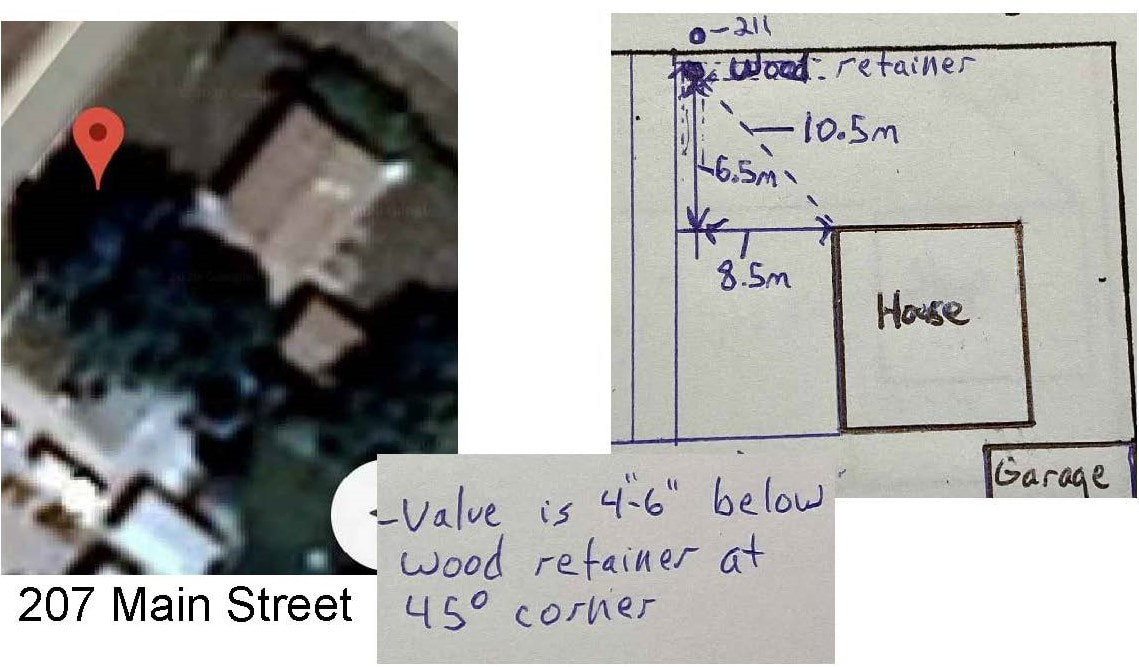
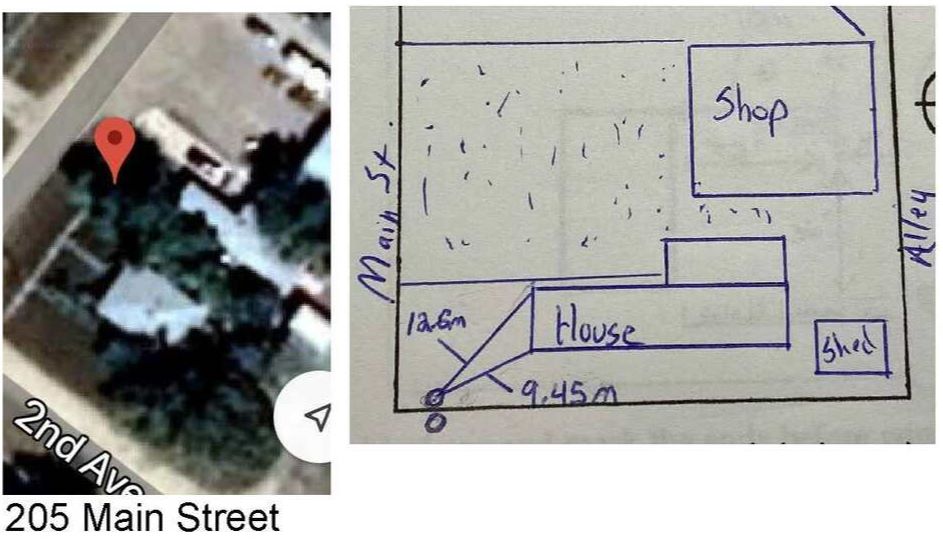
Main Street

calibrated to satellite photo: UTM NAD83 Zone 13 5557877.599 N, 539504.4936 E, LAT N50.1018, LONG W104.2648
calibrated to satellite photo: UTM NAD83 Zone 13 5557910.6909 N, 539528.9442 E, LAT N50.102, LONG 104.2647W
|
calibrated to satellite photo: UTM NAD83 Zone 13N 5557892.8615N, 539546.2408E, LAT N 50.1019, LONG W104.2646
|
calibrated to satellite photo: UTM NAD83 Zone 13N 5557910.9306 N, 539529.1246 E, LAT N50.102, LONG W104.2647
|
calibrated to satellite photo: UTM NAD83 Zone 13 5557936.9876 N, 539579.3889 E, LAT N 50.102, LONG W 104.2645
calibrated to satellite photo: UTM NAD83 Zone 13 (VERY APPROXIMATE) 5557984.8455 N, 539584.3407 E, LAT N 50.1022, LONG W 104.2644
calibrated to satellite photo: UTM NAD83 Zone 13 5558001.625 N, 539595.4873 E, LAT N 50.1022, LONG W 104.2644
|
calibrated to satellite photo: UTM NAD83 Zone 13 5557967.3387 N, 539571.3904 E, LAT N 50.1021, LONG W 104.2645
calibrated to satellite photo: UTM NAD83 Zone 13 5557979.461 N, 539611.3414 E, LAT 50.1022, LONG W 104.2643
|
calibrated to satellite photo: UTM NAD83 Zone 13 5557938.6016 N, 539580.8633 E, LAT N50.102, LONG W 104.2645

calibrated to satellite photo: UTM NAD83 Zone 13 5557979.5189 N, 539611.5949 E, LAT N 50.1022, LONG W 104.2643
|
Queen St & Kelly Farm
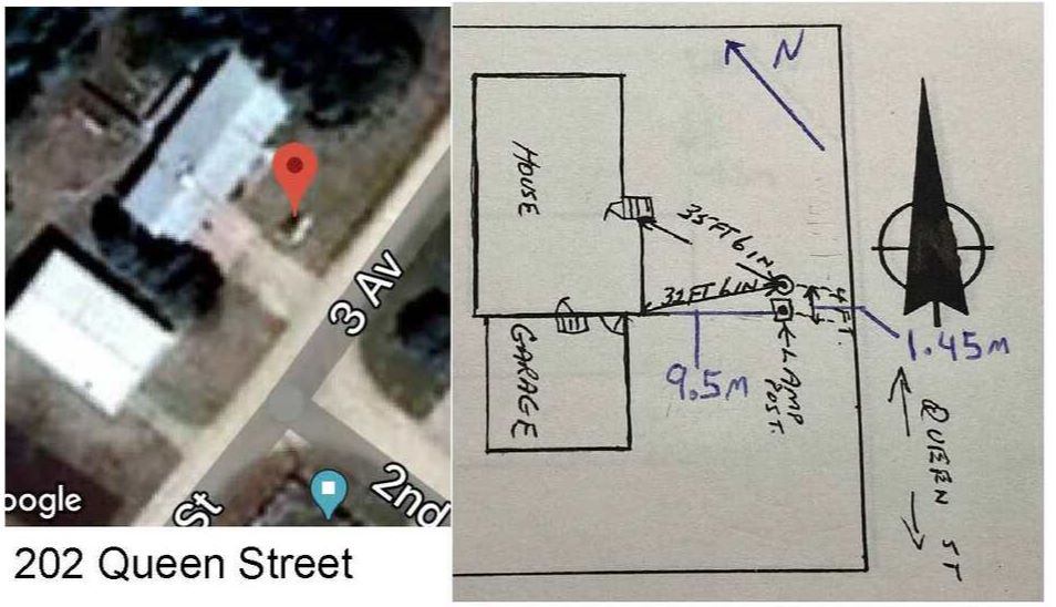
calibrated to satellite photo: UTM NAD83 Zone 13 5558046.1089N, 539414.3321 E, LAT N 50.1024, LONG W 104.2653
|
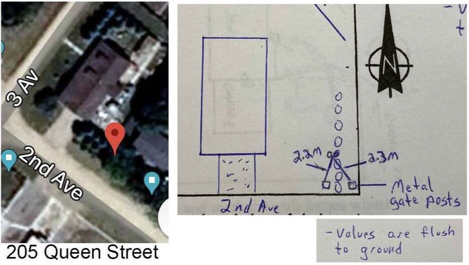
calibrated to satellite photo: UTM NAD83 Zone 13 5558023.988 N, 539459.6042 E, LAT N 50.1023, LONG W 104.2651 APPROXIMATE
|

calibrated to satellite photo: UTM NAD83 Zone 13 5557758.42 N, 539952.6682 E, LAT N 50.1014, LONG W 104.2626 (EXTREMELY APPROXIMATE)
|
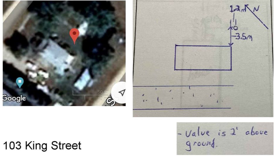
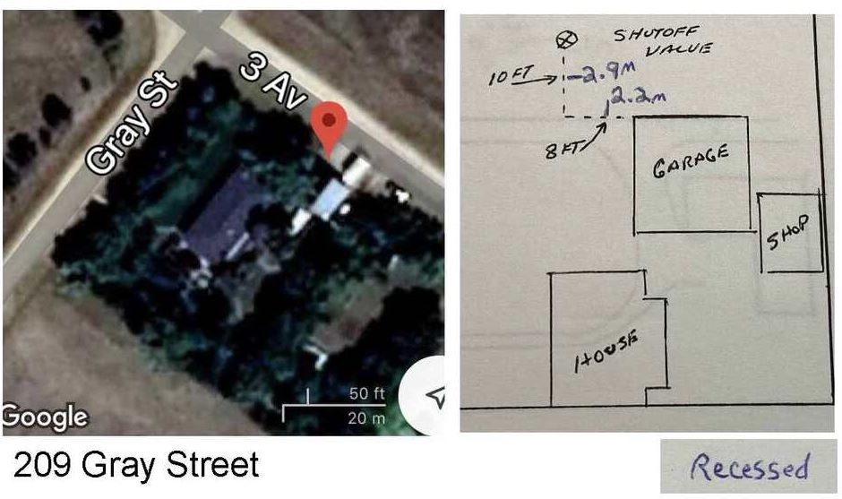
King St, Gray St
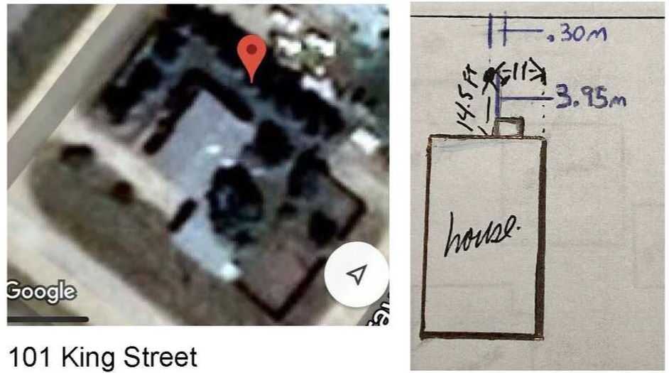
calibrated to satellite photo: UTM NAD83 Zone 13 5557742.6662 N, 539668.7302 E, LAT N 50.1014, LONG W 104.264
|
calibrated to satellite photo: UTM NAD83 Zone 13 5557761.9812 N, 539693.87 E, LAT N 50.1015, LONG W 104.2639
|
calibrated to satellite photo: UTM NAD83 Zone 13 5557842.8989 N, 539837.1702 E, LAT N 50.1017, LONG W 104.2632
|
| water_shut_offs.csv |